Ivan Šumljak (1899–1984) was an all-round mountaineer, blaze maker, writer, photographer and lecturer. On the creation of the trail, he said, “I began working with my friends. We blazed the entire Pohorje. We marked that ridge trail with a Knafelc (uniform) blaze and the number one. When I was resting once at Črni vrh, pleased with the work we’d accomplished, I had an idea: what if the trail marked number one was extended - to Uršlja gora, Smrekovec, Raduha, the Savinja Alps, the Karavanke, the Julian Alps, from Karst to the sea and through the Notranjska and Dolenjska regions back to the Štajerska region and Maribor. A traveller would thus see the beauty of the entire alpine world.”
The Alpine Association of Slovenia is one of the largest and oldest voluntary organisations in Slovenia, and is currently celebrating its 120th anniversary. The Association includes 278 mountaineering societies, with a total of 57,520 members. The mountaineering societies manage 175 mountain huts, shelters and bivouacs, with about 6,000 beds and a network of 1,661 mountain trails with a total length of 9,000 kilometres. The cultural mission of the association is carried out through Planinski vestnik (The Mountaineering Gazette), the oldest Slovenian magazine still being published; its first edition came out in 1895. The Alpine Association of Slovenia was a partner in the construction of the new Slovenian Alpine Museum which opened in Mojstrana in 2010.
The Slovenian Mountain Trail was the first connective mountain trail in the world. The idea was adopted in all Alpine countries and elsewhere, although it was criticised at first for not being appropriate for mountaineering. The individual mountaineering societies which make up the Alpine Association of Slovenia maintain the trail. Ivan Šumljak, its conceptual and operational creator, first designated it as a main path. At its opening in 1953, it was called the Slovenian Alpine Transversal; it acquired its present name in 1991.
In a curve from the mountains to the sea
The large curve of the Slovenian Mountain Trail which connects forests, mountains and sea, consisted initially of 80 control points. Today, it has 75 points over a length of about 600 kilometres. Added together, the climbs on the Slovenian Mountain Trail amount to over 45 kilometres. In addition to this one, an extended trail traversing less mountainous areas of Slovenia with individual unconnected points was established in 1968. A log is needed for this trail, and a guidebook is also available (the latest updated version was published in 2012 by the Planinska založba publishing house).
Walk slowly, my friend!
The Slovenian Mountain Trail passes 58 mountain huts where you can get a stamp to prove that you actually walked the trail. The Knafelc blaze, sometimes accompanied by the number one, guides hikers along the trail, where beginners can systematically acquire mountaineering knowledge, skills and experiences. After walking the whole trail, beginners become experienced and well-rounded mountaineers with the firm spiritual qualities that such a trail offers forms and preserves. The Slovenian Mountain Trail is thus not intended solely for accumulating stamps. Ivan Šumljak advises, “Walk slowly, my friend. You can actually finish the transversal in a month, but it is the best if you walk for five years. You will benefit from it more, much, much more. The badge of honour will still be waiting for you.”
Estimates vary as to how quickly you can walk the Slovenian Mountain Trail. If you walk moderately without breaks, it would take 28 days (in 2012, Pija Peršič took 30 days; more at https://www.facebook.com/pages/HODIM-TOREJ-SEM/103495659799214). According to the latest reliable information, only seven people have managed to run the trail in less than 14 days. Klemen Triler set the current record in 2012 of 8 days, 14 hours and 45 minutes.
Walking for the view
The Slovenian Mountain Trail includes ascents to 23 separate peaks. Personal mountaineering equipment (boots, backpack) suitable for your planned climbing goal (do not forget to take a helmet and self-belaying kit for very demanding trails), a camera and good mood are essential when you walk the trail. Before you start, check the short-term weather forecast for the region and do not overestimate your abilities. If you want to spend a night in a mountain hut, check its opening hours and book a reservation in advance. An Alpine Association of Slovenia guide or an Alpine guide can also accompany you on the trail.
Some 9,500 mountaineers have so far completed the Slovenian Mountain Trail, all of whom received commemorative badges.
Meetings on trails
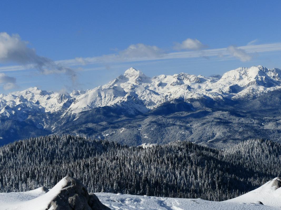
A walk along the Slovenian Mountain Trail is an excellent opportunity to experience the beauty of the Slovenian landscape, to discover cultural sites, signs along the path, flora and fauna, hear the diverse dialects of the local residents and admire the architecture. You will be accompanied by the murmur of waterfalls, streams and rivers, and you can climb the highest peaks and fill your heart and soul at a sunset or an early morning dawn. The magic of the mountain landscape enriches the body and spirit.
The most heartfelt and genuine meetings are those with the local people in the various regions. Different seasons, weather conditions and our own attitude ensure that we never forget the impressions that the trail makes on us. And that is the reason that so many people return to it time and again, or at least to individual parts which they have come to love in particular. See you on the Slovenian Mountain Trail!
Borut Peršolja and Slavica Tovšak, SINFO
On the Slovenian Mountain Trail – in brief (adapted by Borut Peršolja as recorded by Janez Černilec)
The Slovenian Mountain Trail begins in Radvanje near Maribor (270 m) where it ascends to Pohorje, a 60-kilometre mountain chain with the highest point at Črni vrh (1,543 m), and numerous mountain huts and ski tows. In the west, the trail descends to Slovenj Gradec (420 m) and then ascends to Carinthian monadnock, Uršlja gora (1,699 m). From here, the trail continues over Smrekovec (1,577 m) and Komen (1,684 m) to Raduha (2,062 m) and past Bukovnik (1,327 m), the highest farm in Slovenia, then descends to Solčava (642 m) in the Upper Savinja Valley. Through the picturesque Robanov Kot Landscape Park, the trail approaches the foothills of high mountains for the first time. From Molička planina (1,780 m), with the second oldest Slovenian mountain hut, now renovated, named after Fran Kocbek, the trail ascends via Korošica (1,808 m) to Ojstrica (2,350 m), our second most beautiful mountain. The trail continues to Planjava (2,394 m) and from Kamniško sedlo (1,864 m) to Brana (2,252 m), Turska gora (2,251 m), Skuta (2,532 m) and past Kokrško sedlo (1,793 m) to Grintovec (2,558 m), the highest peak in the Kamnik-Savinja Alps. Via Kočna (2,540 m) and Češka koča mountain hut at Spodnje Ravne (1,542 m), the trail descends to Zgornje Jezersko (880 m), which used to be known as a health resort.
The trail continues to Storžič (2,132 m) with magnificent views and descends via Tolsti vrh (1,715 m) and Kriška gora (1,471 m) to Tržič (515 m), which was once an important industrial town. It then ascends to Dobrča (1,634 m) and past Roblekov dom mountain hut (1,657 m) to Begunjščica (2,060 m) and Stol (2,236 m), the highest peak in the Karavanke, which bears an inscription in Slovenian and German: ‘The mountains of friendship’. The trail continues below the ridge along high mountains to Golica (1,835 m) below which lie extensive meadows famed for their daffodils.
After descending into the valley, the trail leads to Dovje (704 m), where the priest Jakob Aljaž, author of the mountaineering anthem ‘Oj, Triglav, moj dom’ (Oh, Triglav, My Home), worked for many years. From Mojstrana (641 m), home of the Slovenian Alpine Museum, the trail continues through the valley of Vrata past Peričnik waterfall to Aljažev dom mountain hut (1,015 m). A steep trail goes via the remarkable Triglav north wall to Kredarica (2,515 m) with the highest mountain hut in Slovenia and on to Triglav (2,864 m), the highest peak and a symbol of Slovenia, where Aljaž Tower is situated. Via Kriški podi (2,050 m) with high mountain lakes, Razor (2,601 m) and Prisank (2,547 m), the trail continues to Vršič (1,611 m), a mountain pass between the Gorenjska region and Trenta with five mountain huts. The trail to Jalovec (2,645 m), according to many the most beautiful Slovenian mountain, whose image is also in the coat-of-arms of the Alpine Association of Slovenia, is easy at first, but extremely challenging in the final section.
The trail then descends into the valley of Trenta with the spring of the Soča River, Slovenia’s most beautiful river. Through Zadnjica, the trail again ascends to Prehodavce (2,071 m) and into the Triglav Lakes Valley or the Valley of the Seven Lakes (1,685 m). The present Triglav National Park has its origins here. From Komna (1,520 m) and along the Krn Lakes (1,385 m), the trail ascends to Krn (2,244 m) which offers beautiful views. The trail continues along the northern slope of the Lower Bohinj Mountains from Vogel (1,922 m) to Črna prst (1,844 m), below which a new mountain hut was built recently at the site of the former oldest Slovenian mountain hut, the Orožen hut. The trail continues to the Cerkljansko and Idrijsko Hills to Idrija (325 m), which once boasted the second largest mercury mine in the world.
From Trnovski gozd and Javornik (1,240 m) further to Nanos (1,313 m) and via Vremščica (1,027 m) to Slavnik (1,028 m), the last 1,000-metre mountain on the trail. It is not far now to the Adriatic Sea, where the Slovenian Mountain Trail ends in Ankaran (8 m).
Ivan Šumljak (1899–1984) was an all-round mountaineer, blaze maker, writer, photographer and lecturer. On the creation of the trail, he said, “I began working with my friends. We blazed the entire Pohorje. We marked that ridge trail with a Knafelc (uniform) blaze and the number one. When I was resting once at Črni vrh, pleased with the work we’d accomplished, I had an idea: what if the trail marked number one was extended - to Uršlja gora, Smrekovec, Raduha, the Savinja Alps, the Karavanke, the Julian Alps, from Karst to the sea and through the Notranjska and Dolenjska regions back to the Štajerska region and Maribor. A traveller would thus see the beauty of the entire alpine world.”
The Alpine Association of Slovenia is one of the largest and oldest voluntary organisations in Slovenia, and is currently celebrating its 120th anniversary. The Association includes 278 mountaineering societies, with a total of 57,520 members. The mountaineering societies manage 175 mountain huts, shelters and bivouacs, with about 6,000 beds and a network of 1,661 mountain trails with a total length of 9,000 kilometres. The cultural mission of the association is carried out through Planinski vestnik (The Mountaineering Gazette), the oldest Slovenian magazine still being published; its first edition came out in 1895. The Alpine Association of Slovenia was a partner in the construction of the new Slovenian Alpine Museum which opened in Mojstrana in 2010.


